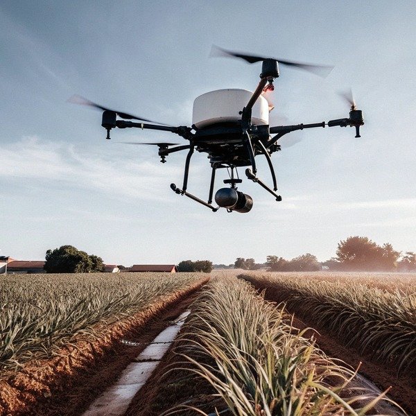
We frequently encounter clients who are disappointed when their “autonomous” drones drift off course or fail to maintain consistent spray heights. During our extensive flight controller testing flight controller 1 at our facility, we realized that vague inquiries often lead to purchasing hardware that requires constant pilot correction. To ensure you get a machine that truly handles the workload, you need to ask precise technical questions about how the flight computer manages the A-B lines.
To accurately assess A-B point automation, ask specific questions about the drone’s ability to maintain centimeter-level accuracy using RTK, its obstacle avoidance behavior during straight-line flights, and whether it supports breakpoint memory for seamless battery swaps. Verify if the system allows autonomous U-turns and offline path persistence without radio connection.
Let’s break down the exact technical details you need to verify with your supplier before signing that purchase order.
What specific questions should I ask about terrain following capabilities during A-B point flights?
In our field trials across diverse topographies, we found that maintaining consistent spray height over uneven ground is critical for effective pest control. Without proper radar integration, even a slight slope can ruin the spray pattern or cause a dangerous crash, so probing the sensor specifications is vital.
You must ask if the drone utilizes millimeter-wave radar for real-time terrain following that automatically adjusts altitude during A-B legs. Confirm the system’s reaction speed to sudden slope changes and whether the altitude hold function remains active during automated turns to ensure consistent crop coverage.

When we engineer flight control systems, we know that “altitude hold” is a term often used loosely in marketing materials. However, in the field, the difference between a barometric altimeter and a high-precision radar barometric altimeter 2 is the difference between a successful harvest and a crashed drone. When asking suppliers about terrain following, you need to dig deeper than just asking “does it follow the ground?” You need to understand the mechanism behind it.
The Technology Behind Height Stability
The standard for modern agricultural drones is millimeter-wave radar (mmWave) millimeter-wave radar 3. millimeter-wave radar 4 Unlike optical sensors or barometers, mmWave radar can penetrate dust, fog, and light crop canopies to find the true ground level. When you speak to a supplier, ask specifically about the frequency of the radar update. A radar that updates its reading 50 times per second (50Hz) will react much smoother to a sudden hill than one that updates only 10 times per second.
Furthermore, you must ask about the "blind zone" and the "max slope angle." Every radar has a minimum detection distance. If the drone flies too low, it might lose the ground signal. Conversely, if the slope is too steep (e.g., greater than 30 degrees), the radar beam might reflect away from the drone rather than back to it, causing a loss of data.
Critical Questions for the Engineering Team
When evaluating a supplier, do not settle for "yes/no" answers. Use the following criteria to challenge their claims. We often see buyers realize too late that their drone cannot handle terraced fields because they didn't ask about the maximum ascent rate.
| Feature | What to Ask | Desired Answer |
|---|---|---|
| Sensor Type | "Is the terrain following based on barometer, GPS, or mmWave Radar?" | mmWave Radar is essential for accuracy. |
| Response Speed | "What is the maximum slope angle the drone can climb at full speed (e.g., 6m/s)?" | Should be at least 15-20 degrees at operational speeds. |
| Canopy Penetration | "Does the radar detect the top of the crop or the soil below?" | Adjustable or soil-detection is preferred to prevent rising too high over tall crops. |
| Turn Logic | "Does terrain following disengage during the U-turn at the end of the row?" | It should remain active to prevent crashing into rising terrain during turns. |
The Impact of "Smoothing" Algorithms
Another aspect we focus on during development is the software "smoothing" of terrain data. If the drone reacts to every single rock or divot, the flight will be jerky, wasting battery and stressing the motors. If it reacts too slowly, it will crash into a hill. Ask the supplier if their software allows you to adjust the "sensitivity" of the terrain following. Being able to tune this setting allows you to adapt the drone for flat wheat fields versus rugged vineyards. This level of control is often the hallmark of a professional-grade flight controller versus a hobbyist conversion.
How do I verify if the drone supports breakpoint memory to resume operations automatically after battery swaps?
Nothing wastes more operational time than manually finding where you left off after a battery change. When we design our mission software, we prioritize robust “resume logic” to ensure large fields are covered efficiently, minimizing the downtime between the inevitable battery swaps required for heavy lifting.
Ask the supplier if the flight controller automatically records the exact GPS coordinate and spray status upon low battery or tank depletion. Verify that the “resume” function autonomously returns the drone to that specific breakpoint to continue the A-B path without duplicating spray or leaving gaps.

Efficiency in agricultural drone operations is purely a numbers game. If a drone takes 15 minutes to deplete a battery but requires 5 minutes of manual piloting to get back to the correct starting point, you are losing 25% of your operational day. This is why “Breakpoint Memory” (often called Breakpoint Resume) is a non-negotiable feature for professional operators. However, the implementation of this feature varies wildly between manufacturers.
The Precision of Return Logic
When we test competitor models, we often see drones that return to the general area but miss the exact spray line by a meter or two. This is usually due to a lack of RTK (Real-Time Kinematic) precision Real-Time Kinematic 5 during the resume phase. You must confirm that the breakpoint coordinate is saved with RTK precision. A deviation of even 50cm results in a "skip" (untreated crop) or an "overlap" (double chemical dose), both of which are unacceptable in precision agriculture precision agriculture 6.
Sequence of Operations
You should ask the supplier to walk you through the exact logic sequence of a breakpoint resume. A sophisticated system should behave as follows:
- Event Trigger: Low battery or empty tank is detected.
- Marking: The drone records the coordinate and the heading.
- Return: The drone returns to home (RTH).
- Swap: Operator changes battery/refills tank.
- Upload: The mission is re-uploaded (or confirmed).
- Transit: The drone flies to the breakpoint at a safe altitude.
- Descent & Engagement: The drone descends to the working height and, critically, starts the pump milliseconds before moving forward to ensure no gap is left.
Evaluating the Software Workflow
The user interface plays a huge role here. Ask to see a demo of the software screen during a battery swap. Is it a one-button process, or does the pilot have to manually select the last point?
| Feature category | Key Inquiry | Why it matters |
|---|---|---|
| Pump Control | "Does the pump start priming before the drone resumes forward motion?" | Prevents a 1-2 meter gap of unsprayed crop where the drone accelerates. |
| Tank vs. Battery | "Does the system distinguish between 'Empty Tank' return and 'Low Battery' return?" | Empty tank return should happen immediately; low battery might have a buffer. |
| Obstacle Memory | "If the drone dodged an obstacle just before the breakpoint, will it remember that on return?" | Prevents the drone from flying straight into the tree it avoided 10 minutes ago. |
The "Drift" Problem
Without RTK, GPS drift can change the perceived location of the drone GPS drift 7 by several meters between the time it lands and the time it takes off again. If the supplier tells you their drone supports breakpoint resume but does not require RTK, be very skeptical. In our experience, standard GPS is not stable enough to resume a spray line perfectly after a 10-minute interval. Always insist on seeing data or a video demonstration of the drone resuming a line to verify the precision.
What details do I need to request regarding obstacle avoidance reliability on the A-B flight path?
We have seen many drones stop indefinitely when facing a thin wire or a stray branch, freezing the entire operation. To avoid this frustration, our engineers spend months calibrating sensors to distinguish between phantom obstacles and real hazards, ensuring the mission continues smoothly whenever possible.
Request detailed specifications on the sensor fusion used for obstacle avoidance, specifically how it handles thin objects like power lines during automated flight. Ask if the drone autonomously reroutes around obstacles to continue the A-B path or if it simply hovers and awaits manual pilot intervention.

Obstacle avoidance is perhaps the most complex Obstacle avoidance 8 and critical safety feature on an agricultural drone. The A-B operation mode is designed for speed and consistency, but fields are rarely empty canvases. They contain utility poles, trees, pump houses, and the most dangerous enemy of all: power lines. power lines 9 When interviewing a supplier, you need to determine if their system is “active” or “passive.”
Passive vs. Active Avoidance
A "passive" system (common in lower-end models) will detect an obstacle and simply stop the drone. It will hover there until the battery dies or the pilot takes control. While safe, this defeats the purpose of automation. An "active" system (Level 3-4 autonomy) will detect the obstacle, calculate a safe bypass route, execute the maneuver, and then return to the original A-B line to continue the job.
You should ask: "If the drone encounters a utility pole in the middle of a spray run, will it fly around it automatically?" If the answer is no, be prepared for high operator fatigue, as the pilot must watch the drone constantly.
Sensor Fusion Technology
Relying on a single sensor type is risky. We advocate for "sensor fusion," which combines sensor fusion 10 data from cameras (vision) and radar.
- Vision Sensors: Good for recognizing shapes but struggle in low light or bright glare.
- Radar: Excellent for distance and night operation but can struggle with resolution on very thin wires.
Ask the supplier how their drone performs at night. Many agricultural operations happen continuously. If the drone relies solely on visual cameras for obstacle avoidance, it is useless after sunset. A radar-based system is mandatory for 24-hour operations.
Obstacle Avoidance Checklist
Use this table to evaluate the robustness of the supplier's safety features.
| Obstacle Type | Difficulty | Question to Ask Supplier |
|---|---|---|
| Power Lines | High | "What is the minimum diameter of wire the radar can detect at 5 meters?" |
| Moving Objects | Medium | "Does the system react to moving obstacles (like tractors or livestock) differently than static ones?" |
| Dust & Spray | High | "Does the radar filter out the drone's own spray mist, or will it trigger false stops?" |
| Night Ops | Medium | "Is the obstacle avoidance system fully functional in total darkness?" |
The "False Positive" Challenge
One of the biggest headaches for operators is a drone that stops for no reason because it thinks a tall weed or a cloud of dust is a wall. This is called a false positive. Ask the supplier about their "filtering algorithms." Advanced flight controllers allow the user to set an "obstacle ignore threshold" or adjust sensitivity. For example, you might want the drone to fly through tall grass but stop for a tree trunk. If the software doesn't allow this customization, you might find the drone refusing to fly in dense crop conditions.
How can I evaluate the software interface to ensure setting A and B points is intuitive and efficient?
Complex software frequently leads to operator error, which can cause skipped rows or chemical wastage. When we export our systems to the US, we ensure our app allows point marking via both the remote controller and actual flight position, accommodating different user habits and field conditions.
Evaluate the software by asking if A and B points can be set using map selection, drone position, and remote controller coordinates. Check if the interface allows for easy adjustments to swath width and flight angle after points are set, and ensure it supports offline map caching for remote areas.

The hardware might be excellent, but if the software interface (Ground Control Station or App) is clunky, your operational efficiency will plummet. The method of setting A and B points determines how quickly you can start a job. In the heat of the season, saving 5 minutes per field adds up to hours of extra productivity per week.
Three Ways to Mark Points
A robust system should offer three distinct methods for defining the field, and you should verify that your supplier supports all of them:
- Drone Position: You fly the drone to Point A, press a button, fly to Point B, and press a button. This is the most accurate method as it uses the drone's RTK positioning.
- Remote Controller Position: You walk to the points with the remote. This is useful if the field is small or if you want to mark boundaries before the drone is even unpacked.
- Map Selection: You tap on a Google Maps/Satellite view on the screen. This is the fastest but least accurate method unless the satellite imagery is high-resolution and georeferenced correctly.
Post-Processing and Adjustability
Once A and B points are set, the software creates a grid of parallel lines. But what if the wind changes? Or what if you need to avoid a neighbor's crop? You must ask the supplier: "Can I rotate the A-B lines by a specific degree after they are generated?" and "Can I nudge the entire grid left or right by 50cm?"
These "nudge" features are essential. Sometimes the GPS map shifts slightly. Being able to nudge the flight plan on the fly saves you from having to re-fly and re-mark the A and B points.
Offline Capabilities
In many agricultural regions, cellular data coverage is non-existent. We always advise clients to verify "Offline Mode."
- Map Caching: Can you download the satellite maps while at the office (Wi-Fi) and use them in the field without a signal?
- Mission Storage: Does the mission save to the drone, or does it require a constant connection to the remote? If the remote loses connection, the drone must continue its A-B line using the onboard data.
Software Feature Comparison
| Feature | Basic System | Advanced System (What you want) |
|---|---|---|
| Point Marking | Drone flight only | Drone flight, RC walk, Map tap |
| Grid Adjustment | Fixed | Rotatable, Nudge (Left/Right), Expand/Contract |
| Field Saving | Deletes after flight | Saves to library for future seasons |
| Boundary Logic | Basic square | Irregular polygons with exclusion zones |
By focusing on these software capabilities, you ensure that the "brain" of the operation is as capable as the "muscle" of the motors.
Conclusion
Purchasing an agricultural drone is a significant capital investment that hinges on the reliability of its automation. By asking targeted questions about radar-based terrain following, RTK-precision breakpoint memory, active obstacle avoidance, and intuitive software interfaces, you move beyond the marketing hype and assess the true engineering capability of the supplier. Whether you are dealing with us or another manufacturer, demanding these technical details will ensure you acquire a tool that enhances efficiency rather than a toy that requires constant supervision.
Footnotes
1. Defines the core component responsible for drone stability and automation. ↩︎
2. Background information on how barometric altimeters measure altitude. ↩︎
3. Technical explanation of the sensor technology from a leading manufacturer. ↩︎
4. Technical IEEE publication explaining the principles of millimeter-wave radar in sensing. ↩︎
5. Industry-standard explanation of high-precision GNSS positioning. ↩︎
6. Authoritative definition of the farming management concept by USDA. ↩︎
7. Explaining the causes of positional errors in GPS systems. ↩︎
8. Technical overview of obstacle avoidance systems in robotics. ↩︎
9. FAA safety guidelines regarding drone operations near utility infrastructure. ↩︎
10. Definition of the process combining data from multiple sensors. ↩︎


