When we design flight controllers at our Xi’an headquarters, we constantly ask: how can we stop a beginner from crashing on day one? Mistakes happen, but they shouldn’t be costly.
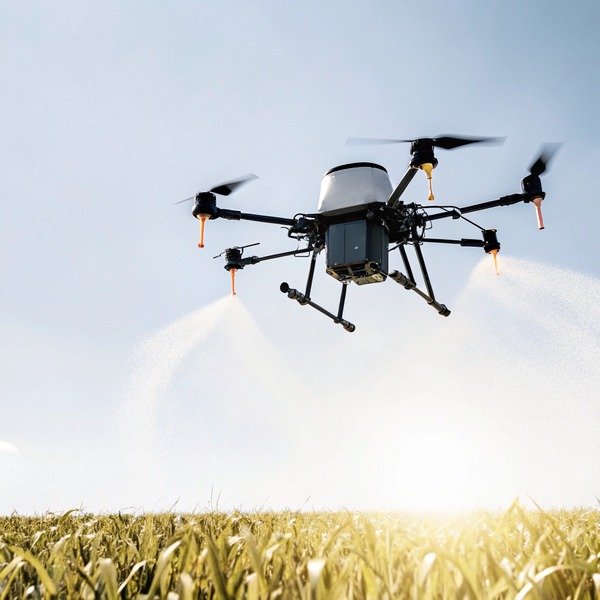
Novice pilots must prioritize agricultural drones equipped with omnidirectional obstacle avoidance radar, automatic Return-to-Home (RTH) failsafes, and terrain-following sensors. Look for autonomous flight planning software and stability controls like GPS mode to minimize manual errors, prevent collisions, and ensure safe operation in complex farm environments.
Let’s examine the specific technologies that keep your investment safe in the field.
How does omnidirectional obstacle avoidance radar prevent collisions for new operators?
We often see damaged frames return to our factory because a pilot didn't see a power line. It is a frustrating and expensive downtime for any farming operation.
Omnidirectional radar systems utilize spherical sensors or binocular vision to detect hazards like wires, poles, and trees in all directions. This technology automatically halts the drone or reroutes flight paths upon detecting obstacles, effectively neutralizing "tunnel vision" and preventing crashes caused by novice pilot error.

In the early days of drone manufacturing, obstacle avoidance was limited to the front obstacle avoidance 1 of the aircraft. This created a significant blind spot when the drone was flying backward or sliding sideways during a spray run. For a novice pilot, spatial awareness is often the hardest skill to master. When you are standing at the edge of a field, it is difficult to judge the exact distance between the drone and a distant tree line.
Modern agricultural drones, including the models we test in our Chengdu facility agricultural drones 2, now use 360-degree spherical radar. Unlike visual cameras, which struggle in low light or heavy fog, millimeter-wave millimeter-wave radar 3 radar works in almost any weather condition millimeter-wave radar 4. It sends out radio waves that bounce off objects, creating a real-time map of the surroundings. If the drone detects a utility pole within a pre-set safety distance (usually 5 to 10 meters), the system overrides the pilot's stick inputs and brakes hard. This is critical for beginners who might panic and push the stick the wrong way.
The Role of Binocular Vision
While radar is excellent for thin wires, binocular vision systems add another layer binocular vision systems 5 of safety. These systems act like human eyes, using two cameras to perceive depth. They are particularly effective at recognizing complex shapes, such as the canopy of a fruit tree or a farm vehicle. By combining radar and vision, the drone creates a "protective bubble" around itself.
Limitations to Consider
However, technology is not magic. Buyers must understand that "omnidirectional" often excludes the top and bottom blind spots directly above the rotors. Furthermore, very thin obstacles like barb wire fences can still be missed if the approach speed is too high. We always advise new pilots to fly slow—under 3 meters per second—when mapping boundaries near obstacles.
Comparison of Sensor Technologies
Here is how different sensors stack up for agricultural safety:
| Sensor Type | Best For | Weakness | Cost Impact |
|---|---|---|---|
| Millimeter-wave Radar | Detecting power lines, night operation, dust/fog penetration. | Cannot distinguish object types (e.g., human vs. tree). | Moderate |
| Binocular Vision | Recognizing 3D shapes, obstacle classification. | Fails in low light or direct sun glare. | High |
| Ultrasonic Sensors | Short-range ground detection. | Short range ( < 5m), affected by sound absorbing surfaces. | Low |
| LiDAR | Extremely precise mapping and distance measurement. | Expensive, can be heavy. | Very High |
Can autonomous flight planning software reduce the risk of manual pilot error?
During our field tests in Chengdu, manual spraying resulted in skipped rows and fatigue. Beginners struggle to maintain consistent lines while watching battery levels and altitude simultaneously.
Autonomous flight planning software significantly reduces risk by allowing pilots to pre-program missions using GPS waypoints, eliminating the need for manual stick control during spraying. This automation ensures precise coverage, reduces operator fatigue, and prevents erratic movements that typically lead to accidents among inexperienced users.

Manual flight is the leading cause of crashes for agricultural drones. manual flight 6 A novice pilot trying to manually fly a heavy drone in straight lines over a 50-acre field will experience fatigue within minutes. "Tunnel vision" sets in, and the pilot may lose orientation, mistaking the front of the drone for the back. This is where autonomous planning becomes a safety feature, not just a productivity tool.
Geofencing and Boundary Limits
Before the propellers even spin, good software allows you to set a "Geofence." This is a digital cage. You walk the perimeter of the field with the remote controller (or an RTK rover) to mark the boundaries. Once the flight begins, the drone physically cannot fly outside this zone. If a novice pilot accidentally pushes the stick toward a neighbor's property or a highway, the software blocks the command. This protects you from liability and keeps the drone in the safe zone.
Reducing Cognitive Load
When a drone flies a pre-programmed route, the pilot transitions from an "operator" to a "monitor." You are no longer worrying about keeping the drone straight. Instead, you are watching the telemetry data: battery voltage, liquid levels telemetry data 7, and signal strength. This shift in focus allows the novice to catch small problems before they become crashes. For example, if the wind picks up, the pilot can see the drift warning on the screen and pause the mission, rather than fighting the wind manually and losing control.
RTK Precision vs. GPS Drift
Standard GPS can drift by 1-2 meters. In a tight field, that drift could put your drone into a tree. We strongly recommend systems with RTK (Real-time Kinematic) positioning. Real-time Kinematic 8 Real-time Kinematic 9 RTK corrects GPS errors to centimeter-level accuracy. This means the flight path you see on the screen is exactly where the drone is in the air. For a beginner, this reliability builds confidence. You know the drone won't suddenly jump sideways due to satellite interference.
Risk Reduction Comparison
| Flight Mode | Primary Pilot Task | Risk Level | Common Accident Cause |
|---|---|---|---|
| Manual Mode | Controlling attitude, speed, and height continuously. | High | Loss of orientation, fatigue, over-correction. |
| AB Point Mode | Setting start/end points; drone flies line. | Medium | Hitting obstacles at the end of the row. |
| Fully Autonomous | Monitoring system health; ready to pause. | Low | Improper mapping setup, unexpected obstacles. |
What fail-safe mechanisms will protect my drone during signal loss or low battery?
Losing connection with a heavy drone is terrifying. We engineer our SkyRover systems to think for themselves when the remote link vanishes, saving your equipment from disaster.
Essential fail-safe mechanisms include automatic Return-to-Home (RTH) protocols triggered by critical battery levels or signal loss. Additionally, intelligent "empty tank" systems record coordinates before returning for refills, while redundant propulsion designs ensure safe landings even if a single motor or propeller fails during flight.

Signal interference is a common issue in rural areas. Large metal barns, high-voltage power lines, or even dense forests can block the signal between the remote and the drone. For a novice, the moment the screen freezes or goes black is panic-inducing. This is why "smart" fail-safes are non-negotiable.
The Logic of Return-to-Home (RTH)
A robust RTH system does more than just fly back. It calculates safety. When the battery hits a critical threshold (calculated based on distance from home), the drone triggers RTH.
- Ascend: First, it climbs to a pre-set safe altitude (e.g., 30 meters) to clear any trees.
- Return: It flies a straight line back to the takeoff point.
- Land: It descends slowly and shuts off motors.
However, we advise users to configure the "Signal Loss" behavior carefully. In some scenarios, hovering in place is safer than returning, especially if flying under a canopy.
Intelligent "Empty Tank" Preservation
Flying with a liquid payload adds complexity. The pump can burn out if it runs dry. Modern systems detect when the tank is empty. The drone immediately marks its GPS coordinate (called a "break point"), shuts off the pump, and returns home. After you refill the tank and swap the battery, one button press sends the drone back to that exact coordinate to resume spraying. This prevents the novice pilot from having to manually navigate back to the middle of a field, reducing flight time and risk.
Electromagnetic Interference (EMI) Detection
Before takeoff, the drone's compass is vulnerable. Rural areas often have hidden magnetic interference from underground pipes or pumps. Good agricultural drones have EMI detection. If the compass is confused, the drone will refuse to arm the motors. This prevents the dreaded "toilet bowl effect," where a drone with a bad compass heading spins uncontrollably immediately after takeoff.
Redundancy in Propulsion
Hexacopters (6 motors) or Octocopters (8 motors) offer a safety advantage over Quadcopters (4 motors). If one motor fails on a Quadcopter, it flips and crashes instantly. On a Hexacopter, the flight controller can overdrive the remaining 5 motors to stabilize the craft, allowing for an emergency landing. For a novice, this redundancy can save a $15,000 investment from total destruction.
Fail-Safe Scenario Table
| Event | Standard Drone Reaction | Novice Benefit |
|---|---|---|
| Remote Signal Lost | Hover for 10s, then climb to Safe Altitude and Return to Home. | Prevents fly-aways when line-of-sight is blocked. |
| Low Battery (Level 1) | Warning on screen; automatic return suggested. | Gives the pilot time to plan a landing. |
| Low Battery (Level 2) | Force landing at current location. | Prevents the drone from falling out of the sky. |
| Empty Tank | Record breakpoint, stop pump, Return to Home. | Protects equipment and ensures complete field coverage. |
| Data Link Error | Drone continues mission but attempts to reconnect. | Mission completion even with spotty video feed. |
Why is terrain following technology essential for maintaining safe flight stability?
We test our sprayers on uneven hills, not just flat concrete. Without automatic height adjustment, a drone will either crash into a slope or fly too high to be effective.
Terrain following technology is critical because it uses radar or ultrasonic waves to maintain a constant height above uneven crops and sloping ground. This prevents ground collisions during uphill flights and ensures consistent spray application, removing the difficulty of manually adjusting altitude while navigating complex topography.

Agricultural fields are rarely perfectly flat. Even a "flat" cornfield has variations in crop height. If a novice pilot sets a manual flight height of 3 meters, and the ground slopes up by 2 meters, the drone is suddenly only 1 meter above the crop. This is a recipe for a crash. Conversely, if the ground drops away, the drone ends up too high, causing the chemical spray to drift into neighboring areas.
How Terrain Radar Works
Terrain following relies on a downward-facing radar module. terrain following 10 Unlike a barometer which measures altitude above sea level, this radar measures "Height Above Ground Level" (AGL). It pings the ground hundreds of times per second.
- Uphill Flight: As the slope rises, the radar detects the distance shrinking. The flight controller automatically increases throttle to maintain the pre-set 3-meter gap.
- Downhill Flight: As the ground drops away, the drone descends smoothly.
This automation is vital for novices because judging vertical distance from 100 meters away is nearly impossible for the human eye.
Dealing with Crop Canopy
The technology is sophisticated enough to differentiate between the ground and the top of the crop. For example, when spraying corn late in the season, the drone needs to fly relative to the tassels, not the soil. Advanced radar settings allow the pilot to choose the reference point. This protects the drone's landing gear from getting tangled in the crop, which is a common cause of motor burnout and crashes.
The Stability Factor
Terrain following also contributes to general flight stability. By locking the vertical axis to the ground, the drone feels "planted" in the air. The novice pilot only needs to worry about horizontal movement. Without this, the pilot is constantly fidgeting with the throttle stick to keep the altitude steady, which leads to jerky, unstable flight. Smooth flight equals safe flight.
Challenges with Complex Terrain
While effective, terrain following has limits. It handles gradual slopes (usually up to 30 or 45 degrees) well. However, it can struggle with:
- Sudden Drop-offs: Like a cliff edge or a deep ditch. The drone might descend rapidly to find the ground.
- Water: Radar waves can reflect oddly off calm water, causing the drone to misjudge height.
- Tall Weeds: A sudden spike in vegetation can cause the drone to jump upwards unnecessarily.
We advise all our clients to map their fields first. Modern 3D flight planning uses a preliminary mapping flight to create a 3D terrain model. The spray drone then follows this digital model rather than relying solely on real-time sensors. This is the safest method for very steep or complex orchards.
Conclusion
Investing in safety features like radar, autonomous planning, and terrain following protects your budget and your liability. Choose a supplier who prioritizes pilot safety to ensure long-term agricultural success.
Footnotes
1. International standards for unmanned aircraft systems and safety-critical obstacle detection. ↩︎
2. Official FAA safety guidelines and registration requirements for commercial agricultural drones. ↩︎
3. Official technical documentation from a major manufacturer explaining the sensor technology. ↩︎
4. Technical explanation of millimeter-wave radar technology used in modern drone sensors. ↩︎
5. Manufacturer documentation on binocular vision technology for obstacle recognition and depth perception. ↩︎
6. Official UK CAA guidance on safe drone operation and pilot responsibilities. ↩︎
7. General background on telemetry data systems used to monitor aircraft health. ↩︎
8. General background definition for the high-precision satellite navigation technique mentioned. ↩︎
9. Research on the implementation of high-precision RTK positioning in precision agriculture. ↩︎
10. Technical specifications for terrain-following radar systems in specialized agricultural aircraft. ↩︎


