When our engineering team first tackled nighttime rescue missions, we discovered that darkness and smoke create the most dangerous conditions for drone operations multi-sensor fusion capabilities 1. Pilots lose visual references. Obstacles appear suddenly. Standard sensors fail when they’re needed most.
To evaluate firefighting drone obstacle avoidance for nighttime rescues, assess multi-sensor fusion capabilities combining thermal imaging, LiDAR, and radar. Test collision prevention in simulated smoke environments with visibility below 10 meters. Verify AI-driven autonomous navigation performs reliably in GPS-denied conditions with at least 95% obstacle detection accuracy.
The following sections break down each critical factor you should examine before committing to a bulk purchase thermal imaging, LiDAR, and radar 2. We’ll cover sensor technologies, real-world testing methods, software customization options, and hardware durability questions for your supplier.
What sensor technology should I prioritize for reliable obstacle avoidance during dark, smoke-filled missions?
Our production line tests dozens of sensor configurations each month, and we've learned that no single sensor type handles all nighttime firefighting challenges AI-driven autonomous navigation 3. Smoke blinds cameras. Heat distorts readings. Darkness removes all visual cues. The solution lies in combining multiple sensor technologies obstacle detection software 4.
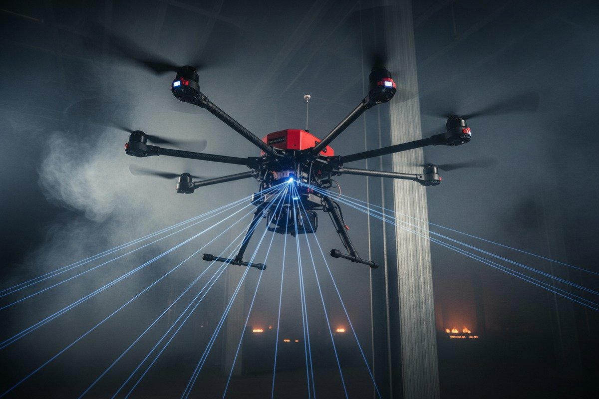
Prioritize multi-sensor fusion systems that integrate thermal imaging, LiDAR, and millimeter-wave radar. Thermal cameras detect heat signatures through smoke. LiDAR provides precise distance measurements in darkness. Radar penetrates dense smoke particles. Together, these sensors deliver 360-degree obstacle detection with over 95% reliability in zero-visibility conditions.

Why Single-Sensor Systems Fail in Fire Environments
Standard visual cameras become useless when smoke density exceeds 50%. We've watched high-definition cameras on our test drones produce nothing but gray images in moderate smoke conditions. Even infrared cameras struggle when flames create excessive heat bloom.
LiDAR alone has limitations too. While laser-based systems excel at measuring distances, they cannot identify heat sources or distinguish between a person and debris of similar shape. Smoke particles can also scatter laser beams, reducing effective range by 30-40% in heavy smoke.
This is why our engineering team recommends multi-directional sensor arrays with at least three complementary technologies working together.
Sensor Technology Comparison for Nighttime Firefighting
| Sensor Type | Smoke Penetration | Night Performance | Heat Detection | Typical Range | Best Use Case |
|---|---|---|---|---|---|
| Thermal/FLIR | Excellent | Excellent | Yes | 100-300m | Victim location, hotspot mapping |
| LiDAR | Moderate | Excellent | No | 50-150m | Precise distance, 3D mapping |
| Millimeter-wave Radar 5 | Excellent | Excellent | No | 30-80m | Dense smoke navigation |
| Ultrasonic | Poor | Good | No | 5-15m | Close-range collision prevention |
| Visual Camera | Poor | Poor | No | Variable | Clear weather operations only |
Critical Sensor Specifications to Request
When reviewing sensor specifications, ask for detection coverage measured in degrees. True 360-degree coverage 6 requires sensors facing all six directions: front, back, left, right, up, and down. Many drones advertise "omnidirectional" sensing but only cover four horizontal directions.
Thermal camera resolution matters significantly. We recommend at least 640×512 pixel thermal sensors for accurate victim detection. Lower resolutions produce unclear heat signatures that lead to false positives.
Update rate is equally important. Sensors should refresh at minimum 10Hz for effective obstacle avoidance during flight speeds of 5-10 m/s. Slower refresh rates create dangerous blind spots between readings.
Finally, verify the sensor's operating temperature range. Firefighting drones operate near extreme heat sources. Quality sensors maintain accuracy from -30°C to 50°C, with temporary exposure tolerance up to 80°C.
How can I evaluate the real-world performance of a drone's collision prevention system before placing a bulk order?
When we ship evaluation units to fire departments across Europe and the United States, we always recommend structured testing protocols. Our clients have wasted thousands of dollars purchasing drones that performed well in showrooms but failed in actual fire conditions.
Evaluate real-world collision prevention by conducting controlled tests in simulated fire environments. Create smoke chambers with visibility below 10 meters using theatrical fog machines. Install obstacle courses with cables, poles, and irregular debris. Measure detection success rate, false positive frequency, and response time. Accept only systems achieving above 95% detection accuracy across 50+ test runs.

Pre-Purchase Testing Protocol
Before committing to any bulk order, request demonstration units for field testing. Reputable suppliers provide evaluation periods of 2-4 weeks. During this time, conduct systematic tests that replicate your operational conditions.
Start with baseline testing in clear conditions. Document detection distances, response times, and maneuver accuracy. This establishes performance benchmarks for comparison against degraded conditions.
Next, introduce environmental challenges progressively. Add smoke, reduce lighting, introduce heat sources, and test GPS denial scenarios 7. Record how performance changes with each added difficulty.
Structured Test Scenarios for Fire Departments
| Test Scenario | Environmental Conditions | Obstacles | Success Criteria |
|---|---|---|---|
| Baseline Clear | Daylight, no smoke, GPS available | Static poles, wires | 100% detection at 20m |
| Low Light | Darkness, no smoke, GPS available | Static and moving obstacles | 98% detection at 15m |
| Light Smoke | 50m visibility, GPS available | Mixed obstacles | 95% detection at 12m |
| Dense Smoke | <10m visibility, GPS available | Mixed obstacles | 90% detection at 8m |
| GPS Denied | Dense smoke, no GPS signal | Mixed obstacles | 85% detection at 8m |
Key Performance Metrics to Track
Detection rate measures how often the system correctly identifies obstacles. Calculate this by dividing successful detections by total obstacle encounters across all test runs. Anything below 95% in clear conditions indicates inadequate sensor capability.
False positive rate measures unnecessary avoidance maneuvers triggered by non-existent obstacles. High false positive rates slow mission completion and drain batteries. Acceptable rates stay below 5%.
Response latency measures time between obstacle detection and avoidance maneuver initiation. Emergency firefighting requires response times under 500 milliseconds at typical flight speeds.
Track battery consumption during obstacle-heavy navigation. Some AI systems drain batteries 20-30% faster during intensive processing. This directly impacts mission duration.
Questions to Ask During Demonstrations
Request access to raw sensor data during tests. Trustworthy suppliers provide transparent access to detection logs showing exactly what the system saw and how it responded. Hidden data suggests hidden problems.
Ask about software version and update frequency. Collision avoidance algorithms improve continuously. Systems receiving quarterly updates outperform static software that never improves.
Inquire about failure modes. What happens when one sensor fails mid-flight? Quality systems include redundancy that maintains safe operation even with partial sensor loss.
Can I customize the obstacle detection software to better suit the specific urban or forest terrain my team operates in?
Our software development team works with fire departments regularly to tune detection algorithms for local conditions. A drone optimized for dense forest navigation handles obstacles differently than one designed for urban structural fires. Cookie-cutter software wastes capabilities.
Yes, obstacle detection software can be customized for specific terrain types. Urban environments require emphasis on wire and antenna detection with narrow gap navigation. Forest operations need branch filtering to avoid false positives from vegetation. Work with suppliers offering open SDK access or dedicated customization services. Expect 4-8 weeks for terrain-specific algorithm tuning with proper flight data collection.

Urban vs. Forest Terrain Requirements
Urban firefighting drones encounter power lines, communication antennas, building edges, and reflective glass surfaces. These obstacles create specific challenges. Thin wires require high-resolution detection. Glass can create false readings from reflections. Building canyons cause GPS signal multipath errors.
Forest operations introduce entirely different problems. Tree branches, dense canopy, uneven terrain, and wildlife create constant sensor triggers. Without proper filtering, drones stop repeatedly for non-threatening vegetation contacts.
Customization Options by Supplier Type
| Supplier Type | Customization Level | Typical Timeline | Cost Range | Best For |
|---|---|---|---|---|
| OEM with SDK | Full access to parameters | 2-4 weeks | $5,000-15,000 | Large departments with IT staff |
| Manufacturer Partnership | Algorithm co-development | 6-12 weeks | $15,000-50,000 | Specialized terrain needs |
| Standard Product | Preset terrain profiles | Immediate | $0-2,000 | Common environments |
| White Label | Complete custom build | 3-6 months | $50,000+ | Unique operational requirements |
Software Parameters Worth Customizing
Obstacle classification sensitivity determines how the AI categorizes detected objects. Urban settings benefit from higher sensitivity to small objects like wires. Forest settings need reduced sensitivity to moving vegetation.
Minimum clearance distances define how close the drone flies to obstacles during avoidance maneuvers. Tight urban spaces may require reducing defaults from 5 meters to 2 meters. Open forest terrain allows wider margins for safety.
Path planning priorities can emphasize speed, safety, or battery conservation. Emergency rescues prioritize speed. Extended search operations prioritize battery life. Your operational profile should guide these settings.
False positive filtering thresholds control how the AI handles ambiguous sensor readings. Too strict, and the system ignores real obstacles. Too loose, and it stops for every shadow. Tuning these thresholds requires local flight data collection.
The Customization Process
First, collect flight data from your actual operational areas. This means flying the drone extensively through representative terrain while logging all sensor inputs. Most customization projects require 50-100 hours of flight data.
Second, work with the supplier's engineering team to analyze detection patterns. They identify which obstacles cause problems and which false positives occur most frequently.
Third, adjust algorithm parameters based on analysis. This typically involves multiple iteration cycles with test flights between adjustments.
Finally, validate changes through structured testing similar to pre-purchase evaluation. Confirm that improvements don't create new problems elsewhere.
What should I ask my supplier about the durability of obstacle detection hardware in extreme fire environments?
During factory durability testing, we subject sensors to conditions far beyond normal operations. Heat cycling, water immersion, vibration stress, and particulate exposure all reveal weaknesses that specification sheets hide. Our clients need equipment that survives real emergencies.
Ask suppliers for specific IP ratings (minimum IP55), operating temperature ranges (-30°C to 50°C), and documented test results from thermal stress, impact, and particulate exposure testing. Request sensor replacement costs, repair turnaround times, and spare parts availability. Demand warranty terms covering fire environment damage. Reputable manufacturers provide durability test reports and 2-year warranties covering sensor components.

Essential Durability Questions Checklist
What IP rating does the sensor assembly carry? IP55 indicates protection against low-pressure water jets and limited dust ingress. IP56 or higher provides better particulate protection essential for ash-heavy environments.
Has the system undergone thermal cycling tests? Quality manufacturers test components through repeated temperature swings from -30°C to 50°C. Ask for cycle counts and documented results.
What happens when sensors get damaged during operations? Understanding replacement costs and timelines before purchase prevents expensive surprises later. Sensor modules costing $3,000+ with 8-week lead times create serious operational gaps.
Hardware Durability Specifications Comparison
| Durability Factor | Minimum Acceptable | Recommended | Premium |
|---|---|---|---|
| IP Rating | IP54 | IP55/56 | IP67 |
| Operating Temp | -20°C to 45°C | -30°C to 50°C | -40°C to 60°C |
| Wind Resistance | 10 m/s | 12 m/s | 15 m/s |
| Vibration Tolerance | Standard | High | Extreme |
| Sensor Warranty | 1 year | 2 years | 3 years |
| Spare Parts Lead Time | 6-8 weeks | 2-4 weeks | In stock |
Common Failure Points in Fire Environments
Thermal camera sensors degrade from prolonged heat exposure. Glass lenses can crack from rapid temperature changes when moving from cold night air into radiant heat zones. Ask about lens material and thermal shock resistance.
LiDAR systems suffer from particulate contamination 8. Ash and soot accumulating on sensor windows reduces detection range. Confirm whether units have self-cleaning features or require manual maintenance after each deployment.
Wiring connections fail from vibration fatigue. Heat cycles expand and contract materials repeatedly, loosening connections over time. Quality construction uses crimped and sealed connectors rather than simple soldered joints.
Motor bearings wear faster in dusty, hot conditions. Obstacle avoidance relies on stable flight. Worn bearings cause vibration that degrades sensor accuracy.
After-Sale Support Evaluation
Durability extends beyond initial construction quality. Evaluate the supplier's support infrastructure before purchase.
Do they stock spare sensor modules in your region? Suppliers with US or European warehouses provide faster replacements than those shipping everything from overseas factories.
Can they perform remote diagnostics? Modern systems allow suppliers to analyze sensor performance data remotely, identifying problems before complete failure occurs.
What training do they provide for field maintenance? Simple cleaning and calibration procedures performed by your team reduce downtime compared to shipping units for factory service.
Our engineering team recommends requesting references from existing fire department customers. Ask those references specifically about durability and support experiences over 12+ months of operation.
Conclusion
Evaluating firefighting drone obstacle avoidance requires systematic examination of sensors, real-world testing, customization potential, and hardware durability. Use the frameworks above to make informed procurement decisions that protect both your team and investment.
Footnotes
1. Explains how combining multiple sensors enhances drone obstacle detection and navigation. ↩︎
2. Details how these specific sensor technologies combine for superior obstacle detection. ↩︎
3. Explains how AI enhances drone navigation, especially in challenging environments. ↩︎
4. Describes real-time drone obstacle detection software, utilizing computer vision and AI for hazard detection and avoidance. ↩︎
5. Explains the specific role and advantages of millimeter-wave radar in drone obstacle detection. ↩︎
6. Defines what constitutes true 360-degree obstacle detection for drones. ↩︎
7. Discusses the importance of testing drone performance in environments without GPS signals. ↩︎
8. Explains how airborne particles can negatively impact LiDAR sensor performance. ↩︎
9. Provides a definition and importance of IP ratings for drone hardware durability. ↩︎


