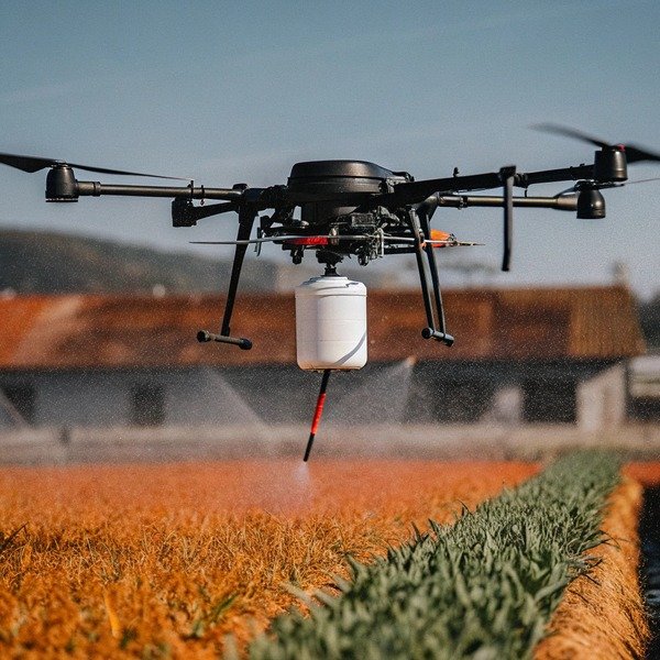
When we test new flight controllers at our Xi’an facility, losing a signal is our biggest fear. losing a signal 1 A crashed drone costs you money and valuable spraying time.
You must evaluate automatic return logic by verifying customizable trigger thresholds for signal loss and battery levels. Ensure the system integrates 360-degree obstacle avoidance sensors like spherical radar or LiDAR. Crucially, confirm the drone supports precise RTK landing to prevent damage and includes smart breakpoint resumption to save mission progress.
Here is exactly what you need to check before signing that purchase order.
Will the drone automatically detect and avoid obstacles during its return flight?
During field trials in Chengdu, we have seen standard return paths fly straight into power lines. Without active sensing, your expensive equipment is at serious risk.
A high-quality agricultural drone must utilize omnidirectional obstacle avoidance, such as spherical radar or binocular vision, during its return-to-home sequence. The system should autonomously detect barriers like trees or poles, stop immediately, and calculate a safe bypass route or hover until the connection is re-established.

The difference between a drone that survives a signal loss and one that crashes often lies in its sensor suite. sensor suite 2 Early models of agricultural drones used a simple "straight-line" return logic. When the signal was lost, the drone would turn toward the home point and fly in a straight line. If a tree or utility pole was in that line, the drone would hit it.
Today, you must demand active obstacle avoidance. تجنب العوائق النشط 3 This system works independently of the pilot. When we design our SkyRover systems, we integrate specific radar modules that stay active even during an emergency return.
Key Sensor Technologies
There are two main technologies you will see in the market. You need to know the difference to make the right choice for your farm environment.
- رادار الموجات المليمترية: This is the industry standard for durability. It works well in dust, fog, and bright sunlight. A spherical radar spins or uses phased arrays to see 360 degrees around the drone.
- Binocular Vision (Cameras): These use cameras to "see" obstacles. They are very precise but can struggle in low light or when the sun is glaring directly into the lens.
The Bypass Logic
You should ask your supplier exactly كيف the drone reacts. Does it stop and hover? Or does it fly around the object?
A "stop and hover" logic is safer but might drain the battery if the drone is far away. A "smart bypass" logic calculates a new route around the obstacle. For large fields with scattered trees, the bypass feature is essential. It ensures the drone continues its journey home without human help.
Radar Specs to Verify
When you look at the spec sheet, check the detection range. A drone flying at 8 meters per second needs time to stop.
| الميزة | المتطلب القياسي | Advanced Performance |
|---|---|---|
| نطاق الكشف | 20 مترًا | 40-50 meters |
| مجال الرؤية | Horizontal only | اتجاهي (360 درجة) |
| Condition Handling | Fails in heavy dust | Works in dust and light rain |
| Reaction | Braking only | Braking and Rerouting |
If you operate in areas with many power lines, ensure the radar is sensitive enough to detect thin wires. radar is sensitive 4 Many basic radars miss cables less than 1cm thick.
Can I manually configure the return altitude to suit different farm terrains?
Our engineering team knows that a fixed return height works for flat fields but fails in orchards. Inflexible settings can lead to disastrous collisions with tall trees.
Yes, you should be able to manually set a “safe return altitude” in the flight software that exceeds the tallest obstacle in your operating area. Advanced systems also offer “Dynamic Home Points” that allow the drone to adjust its return path relative to the pilot’s moving position.

Setting the Return-to-Home (RTH) altitude is one of the first things we teach our clients. Return-to-Home (RTH) altitude 5 If you skip this step, the automatic logic can actually cause a crash.
How the Sequence Works
When the drone loses signal, it does not fly home immediately. It follows a specific "Elevate and Return" logic.
- Brake: The drone stops moving.
- Assess Altitude: It checks its current height against your pre-set RTH altitude.
- الصعود: If the drone is أدناه the RTH altitude (e.g., spraying at 3 meters, RTH set to 20 meters), it climbs to 20 meters.
- العودة: Once at 20 meters, it flies to the home point.
If you set the altitude too low, the drone might crash into a tree during the return. If you set it too high, you waste battery energy climbing up and down. High altitudes also expose the drone to stronger winds.
Handling Hilly Terrain
Flat fields are easy. Hills are difficult. If your home point is at the bottom of a hill, and the drone flies behind the hill, a standard return altitude might not be enough.
For example, if the hill is 30 meters high, and your RTH is set to 20 meters relative to the takeoff point, the drone will crash into the hillside.
You need software that supports "Relative Altitude" or checks the terrain height. Some modern controllers use terrain-following radar to adjust the return height dynamically. This ensures the drone stays 20 meters above the ground beneath it, not just the takeoff point.
Recommended Settings
We recommend different settings based on the environment.
| نوع التضاريس | Recommended RTH Strategy | لماذا؟ |
|---|---|---|
| Open Field | 20-30 متراً | Clear of machinery; minimizes wind drag. |
| البساتين | 5-10 meters above tallest tree | Trees are the primary hazard. |
| Hilly Areas | وضع تتبع التضاريس | Prevents collision with rising slopes. |
| Near Power Lines | Below lines (if possible) or well above | Wires are hard to detect; safe margin is key. |
Always check if the software allows you to change these settings in the field. You do not want to be stuck with a factory default setting when you move to a new job site.
How precise is the landing point when the drone returns without a control signal?
We calibrate our RTK modules to prevent landing drift, which can destroy landing gear. Inaccurate landings often cause the drone to tip over on uneven ground.
Precision depends heavily on the positioning system used; standard GPS may drift by several meters, while RTK-enabled drones achieve centimeter-level landing accuracy. For return-to-home scenarios without a signal, optical flow sensors and downward-facing cameras are essential to verify the landing surface and prevent tipping.

Imagine your drone is returning automatically because the battery is critical. It arrives at the home point, but the GPS is off by two meters. It lands with one leg on the road and one leg in a ditch. The drone tips over, breaking the propellers and spilling the chemical tank.
This scenario happens frequently with cheap GPS modules.
The Role of RTK (Real-Time Kinematic)
Standard GPS has an error margin of 1 to 3 meters. In precision agriculture, this is often unacceptable. RTK technology corrects this error using a base station or a network connection. RTK technology 6 RTK technology 7
With RTK, the return accuracy tightens to within centimeters. This is vital if you are landing on a charging station or a small truck bed. When we export units to the US, we strongly advise customers to use RTK dongles if they plan to use automated landing features.
Landing Protection Sensors
Even with RTK, the ground might have changed. A car might be parked in the landing spot. A dog might run underneath.
You need to evaluate the "Landing Protection" logic. This uses downward-facing cameras and ultrasonic sensors. مستشعرات فوق صوتية 8 Before the drone touches down, it scans the ground.
- Surface Check: Is the ground flat?
- Obstacle Check: Is there something moving below?
- Water Check: Is it landing in a puddle?
If the sensors detect a problem, the drone should hover at 1 meter and wait for a command or try to land slightly to the side.
Swarm Deconfliction
If you are running three drones at once, what happens if the controller fails? They all return home.
If they all return to the exact same coordinate at the same time, they will collide. Advanced return logic includes "Swarm Deconfliction." This assigns different return altitudes or offsets the landing points for each drone in the fleet.
| الميزة | Standard GPS Logic | RTK + Visual Logic |
|---|---|---|
| الدقة الأفقية | ± 2 meters | ± 10 centimeters |
| Landing Spot Check | None (Blind Landing) | Optical Verification |
| Risk of Tipping | High on uneven edges | Low (Aborts if uneven) |
| Night Landing | Low accuracy | Requires bottom auxiliary light |
What happens if the GPS signal fails while the drone is returning to home?
We design our fallback protocols because GPS jammers or dense canopy can blind a drone. Without a secondary navigation layer, the drone becomes a runaway projectile.
If GPS fails during a return flight, the drone must switch to Attitude (ATTI) mode or rely on visual positioning systems to maintain stability. The safest logic is for the drone to hover in place or initiate a slow vertical landing rather than drifting with the wind.

This is the nightmare scenario. The drone loses connection with your remote controller و loses its GPS lock. This can happen due to solar flares, magnetic interference near high-voltage lines التداخل المغناطيسي 9, or flying under dense tree cover.
The Hierarchy of Failsafes
You need to understand the decision tree the flight controller follows. Good software prioritizes safety over saving the mission.
- Primary Navigation: GPS/RTK. If this fails, the drone cannot hold its horizontal position using satellites.
- Secondary Navigation: Visual Positioning System (VPS). The drone uses cameras to look at the ground texture. It locks onto patterns (like rows of crops) to hold its position.
- Tertiary Navigation: Barometer and IMU (Attitude Mode). The drone keeps its height and stays level, but the wind will push it.
The "Drift" Danger
In Attitude (ATTI) mode, the drone does not know where it is. Attitude (ATTI) mode 10 It only knows which way is up. If there is a 15 mph wind, the drone will drift at 15 mph until it hits something.
When evaluating a drone, ask the supplier: "What is the default behavior on total navigation loss?"
The correct answer should be a controlled descent (Landing). The drone should not try to "fly home" because it does not know where home is. It should try to land immediately to prevent flying away into a highway or a building.
Signal Re-acquisition Logic
Sometimes GPS is lost for only a few seconds. The return logic should have a buffer. It should not panic immediately.
A good system will:
- Hover and Wait: Pause for 10 seconds to see if satellites are found.
- attempt Reconnection: If the signal returns, it resumes the RTH path.
- الهبوط: If no signal after the timeout, it descends.
Evaluating Visual Systems
Visual sensors only work if there is light and texture. They fail over water, snow, or in total darkness.
| السيناريو | GPS Available | VPS Available | Drone Behavior |
|---|---|---|---|
| Normal RTH | نعم | نعم | Flies to Home Point accurately. |
| تداخل مغناطيسي | لا يوجد | نعم | Hovers using cameras; may land if battery low. |
| Total Darkness | لا يوجد | لا يوجد | Drifts with wind (ATTI Mode); Must land immediately. |
We always advise our clients to avoid flying at night if they are in areas with known magnetic interference, as the visual backup will not work.
الخاتمة
Prioritizing robust return logic protects your investment. Evaluate radar integration, RTK precision, and customizable failsafes to ensure your fleet operates safely, even when signals vanish.
الحواشي
1. Official FAA guidelines on lost link procedures for commercial UAS operators. ︎
2. Definition and components of integrated sensor suites in robotics. ︎
3. Technical overview of obstacle avoidance systems in autonomous vehicles. ︎
4. Technical research on the sensitivity of radar systems for obstacle detection in UAVs. ︎
5. Official guide on configuring Return-to-Home safety settings. ︎
6. General background on Real-time kinematic positioning for high-accuracy GPS. ︎
7. Authoritative explanation of Real-Time Kinematic positioning accuracy. ︎
8. Scientific principles of ultrasonic sensors used for proximity detection. ︎
9. Background on how magnetic interference affects electronic navigation systems. ︎
10. Explanation of ATTI flight mode mechanics and usage. ︎


