Wenn wir in unserer Zentrale in Xi'an Flugsteuerungen entwickeln, fragen wir uns ständig: Wie können wir verhindern, dass ein Anfänger am ersten Tag abstürzt? Fehler passieren, aber sie sollten nicht kostspielig sein.
Anfänger müssen Agrardrohnen mit omnidirektionaler Hinderniserkennungsradar, automatischen Return-to-Home (RTH) Notfallsystemen und Geländefolgesensoren priorisieren. Achten Sie auf autonome Flugplanungssoftware und Stabilitätskontrollen wie den GPS-Modus, um manuelle Fehler zu minimieren, Kollisionen zu vermeiden und einen sicheren Betrieb in komplexen landwirtschaftlichen Umgebungen zu gewährleisten.
Lassen Sie uns die spezifischen Technologien untersuchen, die Ihre Investition auf dem Feld schützen.
Wie verhindert omnidirektionale Hinderniserkennungsradar Kollisionen für neue Bediener?
Wir sehen oft beschädigte Rahmen, die zu unserer Fabrik zurückkehren, weil ein Pilot eine Stromleitung nicht gesehen hat. Dies ist eine frustrierende und kostspielige Ausfallzeit für jeden landwirtschaftlichen Betrieb.
Omnidirektionale Radarsysteme verwenden sphärische Sensoren oder binokulare Vision, um Gefahren wie Drähte, Masten und Bäume in allen Richtungen zu erkennen. Diese Technologie stoppt die Drohne automatisch oder leitet Flugrouten um, wenn Hindernisse erkannt werden, wodurch die "Tunnelvision" effektiv neutralisiert und Abstürze durch Fehler von Anfängerpiloten verhindert werden.

In den frühen Tagen der Drohnenherstellung beschränkte sich die Hinderniserkennung auf die Vorderseite Hindernisvermeidung 1 des Fluggeräts. Dies schuf einen erheblichen toten Winkel, wenn die Drohne rückwärts flog oder während eines Sprühvorgangs seitwärts glitt. Für einen Anfängerpiloten ist die räumliche Wahrnehmung oft die am schwierigsten zu meisternde Fähigkeit. Wenn Sie am Rande eines Feldes stehen, ist es schwierig, die genaue Entfernung zwischen der Drohne und einer entfernten Baumreihe einzuschätzen.
Moderne Agrardrohnen, einschließlich der Modelle, die wir in unserer Anlage in Chengdu testen Agrardrohnen 2, verwenden jetzt 360-Grad-Sphärenradar. Im Gegensatz zu Kameras, die bei schlechten Lichtverhältnissen oder starkem Nebel Schwierigkeiten haben, funktioniert Millimeterwellenradar Millimeterwellenradar 3 bei fast jedem Wetter Millimeterwellenradar 4. Es sendet Funkwellen aus, die von Objekten abprallen und eine Echtzeitkarte der Umgebung erstellen. Wenn die Drohne einen Versorgungsmast in einem voreingestellten Sicherheitsabstand (normalerweise 5 bis 10 Meter) erkennt, überschreibt das System die Eingaben des Piloten und bremst stark ab. Dies ist entscheidend für Anfänger, die in Panik geraten und den Steuerknüppel falsch bedienen könnten.
Die Rolle des binokularen Sehens
Während Radar für dünne Drähte hervorragend geeignet ist, bieten binokulare Vision-Systeme eine zusätzliche Sicherheitsebene binokulare Vision-Systeme 5 Sicherheit. Diese Systeme funktionieren wie menschliche Augen und nutzen zwei Kameras, um Tiefenwahrnehmung zu ermöglichen. Sie sind besonders effektiv bei der Erkennung komplexer Formen, wie dem Blätterdach eines Obstbaums oder eines landwirtschaftlichen Fahrzeugs. Durch die Kombination von Radar und Vision schafft die Drohne eine "Schutzblase" um sich herum.
Zu berücksichtigende Einschränkungen
Technologie ist jedoch keine Magie. Käufer müssen verstehen, dass "omnidirektional" oft die direkten toten Winkel oben und unten über den Rotoren ausschließt. Darüber hinaus können sehr dünne Hindernisse wie Stacheldrahtzäune immer noch übersehen werden, wenn die Annäherungsgeschwindigkeit zu hoch ist. Wir raten neuen Piloten immer, langsam zu fliegen – unter 3 Metern pro Sekunde –, wenn sie Grenzen in der Nähe von Hindernissen kartieren.
Vergleich von Sensortechnologien
Hier sind die Unterschiede zwischen verschiedenen Sensoren für die landwirtschaftliche Sicherheit:
| Sensor-Typ | Am besten für | Schwäche | Auswirkungen auf die Kosten |
|---|---|---|---|
| Millimeterwellen-Radar | Erkennung von Stromleitungen, Nachtbetrieb, Durchdringung von Staub/Nebel. | Kann Objekttypen nicht unterscheiden (z. B. Mensch vs. Baum). | Mäßig |
| Binokulares Sehen | Erkennung von 3D-Formen, Hindernisklassifizierung. | Versagt bei schwachem Licht oder direkter Sonneneinstrahlung. | Hoch |
| Ultraschallsensoren | Bodenerkennung auf kurze Distanz. | Kurze Reichweite (< 5 m), beeinträchtigt durch schallabsorbierende Oberflächen. | Niedrig |
| LiDAR | Extrem präzise Kartierung und Entfernungsmessung. | Teuer, kann schwer sein. | Sehr hoch |
Kann autonome Flugplanungssoftware das Risiko menschlicher Pilotenfehler reduzieren?
Während unserer Feldtests in Chengdu führten manuelle Sprühflüge zu ausgelassenen Reihen und Ermüdung. Anfänger haben Schwierigkeiten, gleichmäßige Linien beizubehalten, während sie gleichzeitig den Batteriestand und die Höhe im Auge behalten.
Autonome Flugplanungssoftware reduziert das Risiko erheblich, indem sie es Piloten ermöglicht, Missionen mithilfe von GPS-Wegpunkten vorab zu programmieren, wodurch die Notwendigkeit einer manuellen Steuerknüppelsteuerung während des Sprühens entfällt. Diese Automatisierung gewährleistet eine präzise Abdeckung, reduziert die Ermüdung des Bedieners und verhindert unregelmäßige Bewegungen, die bei unerfahrenen Benutzern typischerweise zu Unfällen führen.

Manuelle Flüge sind die Hauptursache für Abstürze von Agrardrohnen. manueller Flug 6 Ein unerfahrener Pilot, der versucht, eine schwere Drohne manuell über ein 50 Hektar großes Feld in geraden Linien zu fliegen, wird innerhalb von Minuten ermüden. Es tritt eine "Tunnelvision" ein, und der Pilot kann die Orientierung verlieren und die Vorderseite der Drohne mit der Rückseite verwechseln. Hier wird die autonome Planung zu einem Sicherheitsmerkmal, nicht nur zu einem Produktivitätswerkzeug.
Geofencing und Begrenzungsgrenzen
Noch bevor sich die Propeller drehen, ermöglicht gute Software das Festlegen eines "Geofence". Dies ist ein digitaler Käfig. Sie gehen den Feldrand mit der Fernbedienung (oder einem RTK-Rover) ab, um die Grenzen zu markieren. Sobald der Flug beginnt, kann die Drohne diese Zone physisch nicht verlassen. Wenn ein unerfahrener Pilot versehentlich den Steuerknüppel in Richtung des Nachbargrundstücks oder einer Autobahn bewegt, blockiert die Software den Befehl. Dies schützt Sie vor Haftung und hält die Drohne in der sicheren Zone.
Reduzierung der kognitiven Belastung
Wenn eine Drohne eine vorprogrammierte Route fliegt, wechselt der Pilot von einem "Bediener" zu einem "Überwacher". Sie müssen sich nicht mehr darum kümmern, die Drohne gerade zu halten. Stattdessen beobachten Sie die Telemetriedaten: Batteriespannung, Flüssigkeitsstand Telemetriedaten 7, und Signalstärke. Diese Verlagerung des Fokus ermöglicht es dem Anfänger, kleine Probleme zu erkennen, bevor sie zu Abstürzen werden. Wenn beispielsweise der Wind zunimmt, kann der Pilot die Abdriftwarnung auf dem Bildschirm sehen und die Mission pausieren, anstatt manuell gegen den Wind anzukämpfen und die Kontrolle zu verlieren.
RTK-Präzision vs. GPS-Drift
Standard-GPS kann um 1-2 Meter abweichen. In einem engen Feld könnte diese Abweichung Ihre Drohne in einen Baum bringen. Wir empfehlen dringend Systeme mit RTK (Real-time Kinematic) Positionierung. Echtzeit-Kinematik 8 Echtzeit-Kinematik 9 RTK korrigiert GPS-Fehler auf Zentimetergenauigkeit. Das bedeutet, dass der Flugpfad, den Sie auf dem Bildschirm sehen, genau dort ist, wo sich die Drohne in der Luft befindet. Für Anfänger baut diese Zuverlässigkeit Vertrauen auf. Sie wissen, dass die Drohne aufgrund von Satellitenstörungen nicht plötzlich zur Seite springt.
Risikoreduktionsvergleich
| Flugmodus | Primäre Pilotaufgabe | Risikostufe | Häufige Unfallursache |
|---|---|---|---|
| Manueller Modus | Kontinuierliche Steuerung von Haltung, Geschwindigkeit und Höhe. | Hoch | Orientierungsverlust, Ermüdung, Überkorrektur. |
| AB-Punkt-Modus | Festlegen von Start-/Endpunkten; Drohne fliegt Linie. | Mittel | Kollision mit Hindernissen am Ende der Reihe. |
| Vollständig autonom | Überwachung des Systemzustands; bereit zum Pausieren. | Niedrig | Unsachgemäße Kartierungseinrichtung, unerwartete Hindernisse. |
Welche Notfallsysteme schützen meine Drohne bei Signalverlust oder niedrigem Batteriestand?
Der Verlust der Verbindung zu einer schweren Drohne ist erschreckend. Wir entwickeln unsere SkyRover-Systeme so, dass sie selbstständig denken, wenn die Fernverbindung ausfällt, und so Ihre Ausrüstung vor einer Katastrophe bewahren.
Wesentliche Notfallsysteme umfassen automatische Return-to-Home (RTH)-Protokolle, die bei kritischen Batterieständen oder Signalverlust ausgelöst werden. Darüber hinaus zeichnen intelligente "leere Tank"-Systeme Koordinaten auf, bevor sie zum Nachfüllen zurückkehren, während redundante Antriebskonstruktionen sichere Landungen gewährleisten, selbst wenn während des Fluges ein einzelner Motor oder Propeller ausfällt.

Signalstörungen sind in ländlichen Gebieten ein häufiges Problem. Große Metallscheunen, Hochspannungsleitungen oder sogar dichte Wälder können das Signal zwischen Fernbedienung und Drohne blockieren. Für einen Anfänger ist der Moment, in dem der Bildschirm einfriert oder schwarz wird, panikauslösend. Deshalb sind "intelligente" Notfallsysteme nicht verhandelbar.
Die Logik von Return-to-Home (RTH)
Ein robustes RTH-System fliegt nicht nur zurück. Es berechnet Sicherheit. Wenn der Akku einen kritischen Schwellenwert erreicht (berechnet basierend auf der Entfernung von zu Hause), löst die Drohne RTH aus.
- Aufstieg: Zuerst steigt sie auf eine voreingestellte sichere Höhe (z. B. 30 Meter), um Bäume zu überfliegen.
- Rücksendung: Sie fliegt in gerader Linie zum Startpunkt zurück.
- Landen: Sie sinkt langsam ab und schaltet die Motoren ab.
Wir raten den Benutzern jedoch, das Verhalten bei "Signalverlust" sorgfältig zu konfigurieren. In einigen Szenarien ist das Schweben an Ort und Stelle sicherer als die Rückkehr, insbesondere beim Fliegen unter einem Baldachin.
Intelligente "Leer-Tank"-Konservierung
Das Fliegen mit einer flüssigen Nutzlast ist komplex. Die Pumpe kann durchbrennen, wenn sie trocken läuft. Moderne Systeme erkennen, wenn der Tank leer ist. Die Drohne markiert sofort ihre GPS-Koordinate (genannt "Break Point"), schaltet die Pumpe ab und kehrt nach Hause zurück. Nachdem Sie den Tank aufgefüllt und den Akku gewechselt haben, sendet ein Knopfdruck die Drohne zurück zu dieser exakten Koordinate, um das Sprühen fortzusetzen. Dies erspart dem unerfahrenen Piloten die manuelle Navigation zurück zur Mitte eines Feldes und reduziert Flugzeit und Risiko.
Erkennung von elektromagnetischen Störungen (EMI)
Vor dem Start ist der Kompass der Drohne anfällig. Ländliche Gebiete haben oft versteckte magnetische Störungen durch unterirdische Rohre oder Pumpen. Gute Agrardrohnen verfügen über eine EMI-Erkennung. Wenn der Kompass verwirrt ist, weigert sich die Drohne, die Motoren zu starten. Dies verhindert den gefürchteten "Toilettenschüssel-Effekt", bei dem eine Drohne mit schlechter Kompassausrichtung unmittelbar nach dem Start unkontrolliert rotiert.
Redundanz im Antrieb
Hexacopter (6 Motoren) oder Octocopter (8 Motoren) bieten einen Sicherheitsvorteil gegenüber Quadcoptern (4 Motoren). Wenn bei einem Quadcopter ein Motor ausfällt, kippt er und stürzt sofort ab. Bei einem Hexacopter kann die Flugsteuerung die verbleibenden 5 Motoren übersteuern, um das Fluggerät zu stabilisieren und eine Notlandung zu ermöglichen. Für einen Anfänger kann diese Redundanz eine Investition von $15.000 vor der vollständigen Zerstörung retten.
Tabelle der Notfallszenarien
| Ereignis | Standard-Drohnenreaktion | Vorteil für Anfänger |
|---|---|---|
| Fernsteuerungssignal verloren | 10 Sekunden schweben, dann auf sichere Höhe steigen und zum Startpunkt zurückkehren. | Verhindert Kontrollverlust, wenn die Sichtlinie blockiert ist. |
| Niedriger Batteriestand (Stufe 1) | Warnung auf dem Bildschirm; automatische Rückkehr wird vorgeschlagen. | Gibt dem Piloten Zeit, eine Landung zu planen. |
| Niedriger Batteriestand (Stufe 2) | Erzwingt Landung am aktuellen Standort. | Verhindert, dass die Drohne vom Himmel fällt. |
| Leerer Tank | Bruchpunkt aufzeichnen, Pumpe stoppen, zum Startpunkt zurückkehren. | Schützt die Ausrüstung und gewährleistet eine vollständige Feldabdeckung. |
| Datenverbindungsfehler | Drohne setzt Mission fort, versucht aber, die Verbindung wiederherzustellen. | Missionsabschluss auch bei lückenhafter Videoübertragung. |
Warum ist Geländefolgetechnologie für die Aufrechterhaltung einer sicheren Flugstabilität unerlässlich?
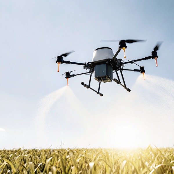
Wir testen unsere Sprühgeräte auf unebenen Hügeln, nicht nur auf flachem Beton. Ohne automatische Höhenanpassung wird eine Drohne entweder in einen Hang stürzen oder zu hoch fliegen, um effektiv zu sein.
Die Geländefolgetechnologie ist entscheidend, da sie Radar- oder Ultraschallwellen verwendet, um eine konstante Höhe über unebenen Pflanzen und abschüssigem Gelände zu halten. Dies verhindert Bodenkollisionen bei Bergaufflügen und gewährleistet eine gleichmäßige Sprühanwendung, wodurch die Schwierigkeit der manuellen Höhenanpassung bei der Navigation in komplexem Gelände entfällt.

Landwirtschaftliche Felder sind selten perfekt eben. Selbst ein "ebenes" Maisfeld weist Unterschiede in der Pflanzenhöhe auf. Wenn ein unerfahrener Pilot eine manuelle Flughöhe von 3 Metern einstellt und der Boden um 2 Meter ansteigt, befindet sich die Drohne plötzlich nur noch 1 Meter über der Ernte. Dies ist eine Garantie für einen Absturz. Umgekehrt, wenn der Boden abfällt, fliegt die Drohne zu hoch, was dazu führt, dass das chemische Sprühmittel in benachbarte Gebiete abdriftet.
Wie das Terrain Radar funktioniert
Die Geländefolgung basiert auf einem nach unten gerichteten Radarmodul. folgendes Terrain 10 Im Gegensatz zu einem Barometer, das die Höhe über dem Meeresspiegel misst, misst dieses Radar die "Höhe über Grund" (AGL). Es sendet Hunderte von Malen pro Sekunde Signale an den Boden.
- Bergaufflug: Wenn der Hang ansteigt, erkennt das Radar, dass die Entfernung schrumpft. Der Flugcontroller erhöht automatisch die Leistung, um den voreingestellten 3-Meter-Abstand einzuhalten.
- Bergabflug: Wenn der Boden abfällt, sinkt die Drohne sanft ab.
Diese Automatisierung ist für Anfänger unerlässlich, da die Beurteilung der vertikalen Entfernung aus 100 Metern Entfernung für das menschliche Auge nahezu unmöglich ist.
Umgang mit dem Pflanzenbestand
Die Technologie ist hochentwickelt genug, um zwischen dem Boden und der Oberseite der Pflanze zu unterscheiden. Wenn beispielsweise spät in der Saison Mais gespritzt wird, muss die Drohne relativ zu den Fahnen, und nicht zum Boden fliegen. Fortgeschrittene Radareinstellungen ermöglichen es dem Piloten, den Referenzpunkt zu wählen. Dies schützt das Fahrwerk der Drohne davor, sich in der Ernte zu verfangen, was eine häufige Ursache für Motorausfälle und Abstürze ist.
Der Stabilitätsfaktor
Die Geländefolgung trägt auch zur allgemeinen Flugstabilität bei. Durch die Fixierung der vertikalen Achse am Boden fühlt sich die Drohne in der Luft "verankert" an. Der unerfahrene Pilot muss sich nur noch um die horizontale Bewegung kümmern. Ohne dies muss der Pilot ständig am Gashebel fummeln, um die Höhe konstant zu halten, was zu ruckartigem, instabilem Flug führt. Sanfter Flug bedeutet sicheren Flug.
Herausforderungen bei komplexem Gelände
Obwohl effektiv, hat das Geländefolgen Grenzen. Es bewältigt sanfte Hänge (normalerweise bis zu 30 oder 45 Grad) gut. Es kann jedoch Schwierigkeiten haben mit:
- Plötzliche Abgründe: Wie eine Klippenkante oder ein tiefer Graben. Die Drohne kann schnell abfallen, um den Boden zu finden.
- Wasser: Radarwellen können von ruhigem Wasser seltsam reflektieren, wodurch die Drohne die Höhe falsch einschätzt.
- Hohes Unkraut: Ein plötzlicher Anstieg der Vegetation kann dazu führen, dass die Drohne unnötigerweise nach oben springt.
Wir raten allen unseren Kunden, ihre Felder zuerst zu kartieren. Moderne 3D-Flugplanung verwendet einen vorläufigen Kartierungsflug, um ein 3D-Geländemodell zu erstellen. Die Sprühdrohne folgt dann diesem digitalen Modell, anstatt sich ausschließlich auf Echtzeitsensoren zu verlassen. Dies ist die sicherste Methode für sehr steile oder komplexe Obstgärten.
Schlussfolgerung
Investitionen in Sicherheitsfunktionen wie Radar, autonome Planung und Geländefolgen schützen Ihr Budget und Ihre Haftung. Wählen Sie einen Lieferanten, der der Sicherheit des Piloten Priorität einräumt, um langfristigen landwirtschaftlichen Erfolg zu gewährleisten.
Fußnoten
1. Internationale Standards für unbemannte Flugsysteme und sicherheitskritische Hinderniserkennung. ︎
2. Offizielle FAA-Sicherheitsrichtlinien und Registrierungsanforderungen für kommerzielle Agrardrohnen. ︎
3. Offizielle technische Dokumentation eines großen Herstellers, die die Sensortechnologie erklärt. ︎
4. Technische Erklärung der Millimeterwellen-Radartechnologie, die in modernen Drohnensensoren verwendet wird. ︎
5. Herstellerdokumentation zur binokularen Visionstechnologie für Hinderniserkennung und Tiefenwahrnehmung. ︎
6. Offizielle UK CAA-Richtlinien für den sicheren Drohnenbetrieb und die Verantwortlichkeiten des Piloten. ︎
7. Allgemeiner Hintergrund zu Telemetriedatensystemen, die zur Überwachung der Flugzeuggesundheit verwendet werden. ︎
8. Allgemeine Hintergrunddefinition für die erwähnte hochpräzise Satellitennavigationstechnik. ︎
9. Forschung zur Implementierung hochpräziser RTK-Positionierung in der Präzisionslandwirtschaft. ︎
10. Technische Spezifikationen für Terrain-Following-Radarsysteme in spezialisierten Agrarflugzeugen. ︎


